Nieuws Tien jaar geleden was de vorige burgemeester van Rotterdam bezorgd over het feit dat Rotterdam eindigde op de bodem van de verkeerde rankings. De World Council on City Data (WCCD) - het internationale online platform voor gestandaardiseerde stedenindicatoren - wil dit probleem aanpakken. Hieronder de eerste twee delen van het artikel (in het engels).
Using local and global data to drive performance
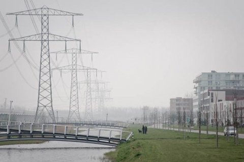
As recent as a decade ago, the previous Mayor of Rotterdam was concerned about, “Rotterdam ending up at the bottom of the wrong rankings.” Today, those concerns have become yesterday’s news as Rotterdam was recently awarded the Academy of Urbanism’s 2015 AAward for European City of the Year.
Many cities share the goals of becoming prosperous and environmentally friendly. They look to create a high quality of life for their citizens. However, a critical question is: how can these goals be accomplished and how can they become self-sustaining? One of the next steps a city must take involves leveraging city data and Geographical Information Systems (GIS) to create informative stakeholder information and to develop efficient planning processes for the city.
Saskia Sassen, Bruce Katz, and Benjamin Barber all write about the growing importance of metropolitan regions and cities in the global context. However, until recently, it was almost impossible to find high quality, verifiable data at a city level. Regions, cities, and neighbourhoods within cities need to utilise benchmarking tools to understand where specific improvements are needed. This process can be approached in several ways – both by interacting directly with local citizens and by leveraging established data (and collecting new data) about specific issues. Like a student concerned about a mediocre grade in school, a city should be concerned with its own performance – as well as where it appears in international rankings. To make these benchmarks useful for improving our policies at the City of Rotterdam, a group of researchers compared available rankings and benchmarks.1 Although existing benchmarks were useful for specific purposes, there were several essential pieces missing from the data, including the following:
Feedback on city scores
Standardized third party verified data
Indicator evolution— as there was no feedback from cities on the rankings
Weighing indicators
Resilience/adaptation capacity
Governance
Use of local potentials (renewables)
Indirect impacts of consumption elsewhere i.e. footprint analysis
USING INTERNATIONAL BENCHMARKS IN ROTTERDAM
In 2010, Rotterdam joined the Global City Indicators Facility (GCIF), based at the University of Toronto, as it addressed some of the aforementioned issues. The GCIF set of indicators was further developed into the first ISO standard for city indicators (ISO 37120), which was launched last May along with the World Council on City Data (WCCD). WCCD worked with 20 Foundation Cities to pilot ISO 37120. By mid-November 2014, this first group of cities became ISO 37120 certified with an additional 100 cities waiting in the wings.
The ISO 37120 Standard, Sustainable development of communities - Indicators for city services and quality of life, provides standardized definitions and methodologies so that cities can compare and learn from other cities globally – specifically through the WCCD Open Data portal, which will be available to the public in early 2015. These International comparisons have brought some interesting insights for the City of Rotterdam. For instance, Rotterdam can now compare itself against similarly sized cities on measures like air quality or kilometres of bicycle paths.
Within the city level data, there is even more specific information that can be gleaned about Rotterdam’s neighbourhoods. Taken together, this cloud of data is used for the following:
1) To generate neighbourhood indices like the safety index, health index, and social
index;
2) To help developers achieve BREEAM, LEED, or other certifications;
3) To provide ranking organisations with better access to the right data in the city;
4) To build apps and software in Hackathons;
5) To get direct feedback from citizens on certain topics using future data related
apps; and
6) For our own policy-purposes. Using data makes it possible to develop more evidence-based
policy. It becomes easier to monitor progress and to determine towhat extent policy goals are reached.
II. SMART CITY PLANNING PROCESS
It is important to collect data that is as comparable as possible on an international scale. Often a ‘per 100,000’ or ‘per capita’ number is required to make international comparisons. In Rotterdam, this data is stored at the lowest level possible and includes geographic references. We use GIS to compute, analyse, and visualise this data, allowing the city to present the data at different levels of aggregation. It also becomes possible to not only show what is happening in the city, but, very specifically, where it is happening. It is easier to read one map than a dozen excel sheets.
However, as soon as the number of themes and indicators grow, it becomes impossible to put hundreds of maps on the table and discuss them meaningfully with stakeholders. To solve this problem, an interface was built which serves as an area profile (see figure 1). The interface uses available data in the city ranging from the social index, precipitation, and energy, to traffic and air quality. It consists of a baseline study of about 100 indicators in 17 themes (related to ISO 37120) for a selected area. The interface shows the key themes through a spider diagram, as well as where ‘data’ occurs using underlying digital maps. The traffic light colours are used to see how the themes and indicators score compared to the city average or a chosen threshold. The selected areas can be scaled from block to block, or include several neighbourhoods, quartiers or the entire city – which consists of ninety neighbourhoods in total. This scalar approach is crucial as it links (ISO) urban standards to projects and activities.
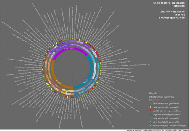
Figure 1: Feyenoord Area profile, one of the Rotterdam neighbourhoods. Each indicator is backed up with scalable GIS maps.
‘Rotterdam’s Smart City Planner - Afbeelding 1’
Accelerator
Thanks to an automated system, an area profile can be composed within half an hour showing the three colours per indicator. The area profile acts like a baseline or thermometer for the area and provides ‘objective’ information about that area. The traffic light colours make it possible to focus on the challenges ahead in that area.
The next step for Rotterdam is to hold a multi-disciplinary forum with engaged citizens and other stakeholders who can range from residents to investors – all with the clear mandate to formulate future goals guided by GIS data. It is very much a stakeholder driven approach. Theoretically, it is possible that two neighbourhoods might have the same challenges presented, but as different stakeholders are active in different areas, some might choose to solve issues on storm water whereas others focus on energy efficiency. The project results can be compared later with the baseline to see if improvements have been made. The whole process is based on informed decision making.
During 2013, this process was used more than thirty times in Rotterdam as a preparatory step ahead of various action plans ranging from water strategies to promoting health and child-friendly neighbourhoods.
Cover: ‘2015.09.17_Rotterdam’s Smart City Planner(4)’

Door Nico Tillie
Researcher and Lecturer, Landscape Architecture, Delft University of Technology & City of Rotterdam | European representative, World Council on City Data